


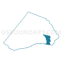
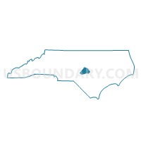
Voting District PR26, Harnett County, North Carolina
About
Outline

Summary
| Unique Area Identifier | 640398 |
| Name | Voting District PR26 |
| County | Harnett County |
| State | North Carolina |
| Area (square miles) | 18.84 |
| Land Area (square miles) | 18.32 |
| Water Area (square miles) | 0.52 |
| % of Land Area | 97.26 |
| % of Water Area | 2.74 |
| Latitude of the Internal Point | 35.29954740 |
| Longtitude of the Internal Point | -78.67205750 |
Maps

Graphs
Select a template below for downloading or customizing gragh for Voting District PR26, Harnett County, North Carolina


Neighbors
Neighoring Voting District (by Name) Neighboring Voting District on the Map
- Voting District G7, Cumberland County, NC
- Voting District LI65, Cumberland County, NC
- Voting District PR17, Harnett County, NC
- Voting District PR20, Harnett County, NC
- Voting District PR24, Harnett County, NC
- Voting District PR25, Harnett County, NC
- Voting District PR29, Harnett County, NC
Top 10 Neighboring County Subdivision (by Population) Neighboring County Subdivision on the Map
- Carvers Creek township, Cumberland County, NC (22,866)
- Averasboro township, Harnett County, NC (13,018)
- Grove township, Harnett County, NC (10,911)
- Duke township, Harnett County, NC (5,976)
- Lillington township, Harnett County, NC (4,892)
- Stewarts Creek township, Harnett County, NC (3,767)
- Black River township, Cumberland County, NC (2,180)
Top 10 Neighboring Place (by Population) Neighboring Place on the Map
Top 10 Neighboring Unified School District (by Population) Neighboring Unified School District on the Map
Top 10 Neighboring State Legislative District Lower Chamber (by Population) Neighboring State Legislative District Lower Chamber on the Map
Top 10 Neighboring State Legislative District Upper Chamber (by Population) Neighboring State Legislative District Upper Chamber on the Map
Top 10 Neighboring 111th Congressional District (by Population) Neighboring 111th Congressional District on the Map
Top 10 Neighboring Census Tract (by Population) Neighboring Census Tract on the Map
- Census Tract 37, Cumberland County, NC (7,322)
- Census Tract 705, Harnett County, NC (5,914)
- Census Tract 707, Harnett County, NC (5,400)
- Census Tract 703, Harnett County, NC (4,907)
- Census Tract 701, Harnett County, NC (4,530)
- Census Tract 706, Harnett County, NC (4,377)
- Census Tract 26, Cumberland County, NC (4,218)
- Census Tract 704.01, Harnett County, NC (3,963)